


Background
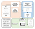
Modelling at the landscape level involves looking beyond field boundaries where management-level practices and activities related to crop-shrub-livestock (CSL) systems are typically implemented on individual farms to meet production objectives. At the landscape scale, different land uses are interconnected making it complex. At this broader scale, a more comprehensive land-based perspective provides a dominant lens through which interventions can be provided. At the same time, understanding how individual fields function in the larger landscape can help in identifying where and how to design CSL systems to be more productive. Several research efforts have assessed the suitability of agroforestry systems (AF) at this scale. Most of these approaches lacked feedback mechanisms between crops, trees/shrubs and livestock components to facilitate systems thinking. Moreover, identifying the suitability of CSL options implies assessing their long-term impacts on farm economy and ecosystem functions. Thus, we present a landscape level modelling approach (Fig. 1) that incorporates remote sensing, GIS and machine learning functionalities to better understand the system responses to climatic and biophysical gradients in identifying the suitability of CSL systems at different landscape locations in semi-arid areas.
Landscape characterization and mapping
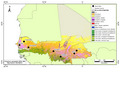
Climatic (precipitation), biophysical (elevation, soil groups, soil organic carbon) and vegetation (land cover-tree/shrub cover) were mapped at the regional scale (Senegal,Mali,Burkina Faso) (Fig. 2) and at the site scale using existing databases e.g., WaPOR, ISRIC, TAMSAT.
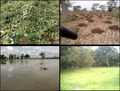
Following this, GPS coordinates on the various land uses and covers (LULC) and woody plants (Fig. 3.) were collected at each study site and used as training data. The LULC types and woody plants were digitized and labelled with a very high spatial resolution (VHSR) image (SPOT6+Sentinel) as a background based on the coordinates. Simultaneously, a Sentinal-2 times series over the crop year (October 2022) was used to process crop LU. Then, a supervised classification was used to produce LU maps with Sentinel images via Google Earth Engine. The LU maps were then converted to PCRaster format for use in the land use change impact assessment (LUCIA) model.
Landscape modelling with LUCIA
The LUCIA model is a spatially explicit and grid-based landscape model developed to simulate plant productivity, soil fertility and ecosystem services such as erosion protection, water retention and soil carbon storage (Marohn and Cadisch, 2011). LUCIA handles various landscape sizes and pixel resolutions, which allows the simulation of agroforestry systems and savanna rangelands with their heterogeneity in soil, vegetation and topography, as well as livestock herd mobility patterns from the LUCIA–LivSim coupled framework.
Model parameterisation and calibration
The LUCIA model was parameterised with data collected on the SustainSahel project sites. Parameters used were spatial maps, plant and soil, weather, management and animals. For calibration, time series data of LAI, NDVI, and FCover of crops and vegetation were computed during different cropping seasons using Sentinel-2 (S2) images. The LUCIA simulated outputs of LAI, groundcover and aboveground biomass were compared to the measured data from S2.
Model scenarios on the suitability of CLS systems
Future model scenarios for evaluating the suitability of CSL systems will concentrate on assessing their performance across various landscape locations. These scenarios will test the systems' potential to enhance resource use efficiency, including biomass production, yields, and resilience to stress factors like limited water, temperature variations, different soil conditions, management practices, and diverse land use patterns over 20 years.
 tap and then scroll down to the Add to Home Screen command.