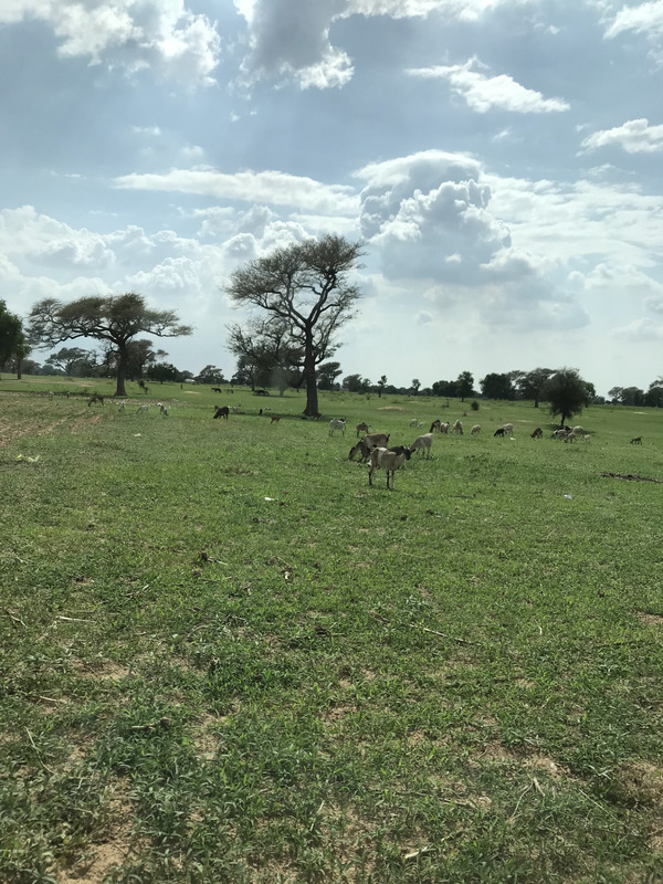
In tropical farming systems (Fig.1), interactions occur between crops, agroforestry, and livestock at different scales (within a field or farm, across a landscape, or globally). At each scale, complexities of interactions exist in both space and time making it difficult to study the processes and to develop models. Hence, simulation models focusing on individual systems have not been successful in addressing the interactions among trees, crops, livestock and the environment, particularly in Sub-Saharan Africa where agricultural and pastoral systems are in close proximity and often intimately linked. Hence, modelling approaches should consider the interactions between agroforestry and livestock across various spatial scales, encompassing interactions among soil, crops, shrubs, grasslands, savannas, and forests at the plot, landscape, and temporal levels. Consequently, there is a need to couple different system models, such as those focusing on livestock, crops, trees, and watersheds, to effectively address this complexity. The difficulty lies in the fact that various models operate at distinct time and spatial scales and that actors shape the interactions between system components. These circumstances necessitate an integrated and transdisciplinary approach that addresses scale-related challenges and incorporates stakeholder perspectives and management vision into the modelling process.
Transdisciplinary modelling framework
(i) Concept
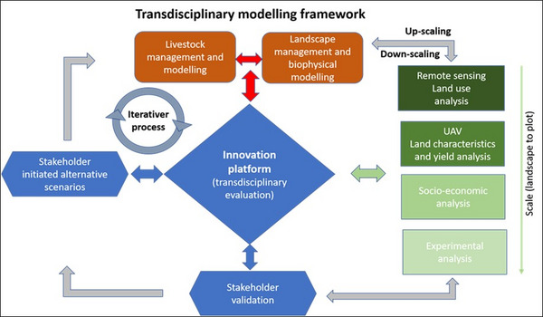
The Plant Production Institute in the Tropics and Subtropics at UHOH brings its expertise in integrated modelling by proposing a transdisciplinary modelling framework (Fig. 2). This framework builds upon locally established innovation platforms where stakeholder problems are identified and alternative management visions are taken into consideration. Throughout this process, stakeholder-preferred scenarios are developed and subsequently transferred into modelling scenarios. During this process scenarios may need to be adapted/simplified to align with the capabilities and outputs of the models. As mentioned earlier, models should address scale-related challenges, encompassing herd management and biomass transfer at the landscape level while reflecting processes at the plot scale. Therefore, integrating dynamic process-oriented sub-models (related to soil, plants, trees, and the landscape) along with coupling livestock models (e.g. LivSim), plant/grassland-watershed models (e.g. LUCIA), and multi-agent socio-economic models (e.g. MPMAS) may be necessary. Although, some questions might also be dealt with simpler model constructs.
After the simulations, the outputs generated by process-oriented models will be adapted to stakeholders understanding and incorporated into the discussion process within the innovation platform. This integration, along with stakeholder validation and feedback, coupled with new knowledge, allows for the modification of the previously defined alternative scenario settings. Importantly, this feedback loop should be an iterative process together with stakeholders that promotes continuous refinement until a satisfactory outcome is achieved.
(ii) Implementation
The process of model parameterization, calibration, and validation requires input at various scales, therefore, a combination of upscaling and downscaling tools is necessary. At landscape, this includes utilizing remote sensing techniques to assess land use, combined with employing UAV applications to characterize land use and potential productivity, as well as conducting socio-economic surveys to understand farmers' management and livelihood strategies. While at the local scale, experimental data are used to test new management options. These scale-dependent inputs serve as vital information for model parameterization. Subsequently, outputs generated by process-oriented models need to be translated into simplified messages according to stakeholders understanding to be incorporated into the discussion process within the innovation platform. Remote sensing tools can also play a role in supporting the upscaling of new process-model output scenarios. This enables regional assessments of certain parameters such as land use change, biomass productivity, and carbon sequestration. By employing remote sensing, a broader understanding of these parameters can be achieved.
Written by: Prof. Dr. Georg Cadisch and Dr. Eric Koomson from University of Hohenheim (UHOH)
Further information
Weblinks
Uni-hohenheim.de:
LUCIA - Land Use Change Impact Assessment tool
MPMAS - Mathematical Programming-based Multi-Agent Systems
Models.pps.wur.nl:


 tap and then scroll down to the Add to Home Screen command.